
A UK Mirror for the VLA Low-frequency Sky Survey
Data Release May 2006
To facilitate access for UK and European users, MRAO is providing a UK Mirror of the VLA Low-frequency Sky Survey (VLSS), which is being produced in the US jointly by NRAO and the Naval Research Laboratory (NRL).
Principal Investigators
- R. A. Perley (NRAO PI)
- National Radio Astronomy Observatory, P.O. Box 0, Socorro, NM 87801
- N. E. Kassim (NRL PI)
- Naval Reseach Laboratory, Code 7213, Washington, DC 20375
General Description
The VLA Low-Frequency Sky Survey (VLSS) is a 74 MHz continuum survey covering the entire sky north of -30° declination. Using the VLA in BnA and B-configurations, we will map the entire survey region at a resolution of 80″ and with an average rms noise of 0.1 Jy/beam. Complete details are in “The VLA Low-Frequency Sky Survey” (2007,AJ,134,1245 – preprint at arXiv:0706.1191v1 [astro-ph])>.
Upon completion, the principal VLSS data products will be:
- A set of 358 continuum images (Stokes I) of size 14°×14° which are distributed on a grid designed such that adjacent images overlap by at least 2°.
- A catalog of discrete sources on these images created by fitting a elliptical Guassians to all sources detected at the 5 sigma level or higher.
The VLSS has been conducted as a service to the astronomical community, and the principal data products were released to the public as soon as they were produced and verified.
Current Survey Status
The second major VLSS data release, representing roughly 95% of the planned survey area, is now available. In addition to the increase in sky coverage, the new data release also contains more accurate data from the previously covered regions. Fields Observed: 492 (out of 523 total), total Source Count: ~67,000

In the map above, the blue shaded area represents the approximate region of the sky available in the first data release (June 15, 2004). The current data release (May, 2006) includes the green-shaded region in addition to the previous blue-shaded region. In both regions, the positional accuracy and noise levels are improved over the first data release.
VLSS survey area
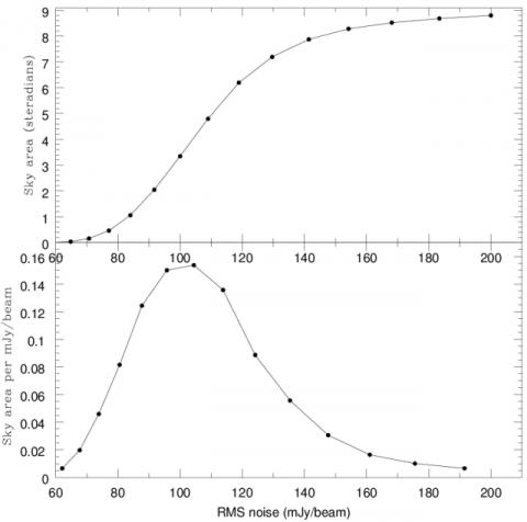
The total region now observed is 9.3 sr. However, the rms noise varies significantly. Most of this region has a rms noise between about 70 and 130 mJy/beam, but it can get much higher near very bright sources (such as Cas A and Cyg A) and within a few degrees of the boundaries of the current survey region. Therefore, we include the above plots to indicate the sky area covered below a given rms noise level and per rms noise interval.
Accessing the data
The primary data product is the grid of 14°×14° images. These are in FITS format and can be read by the major astronomical software packages (AIPS, IRAF, etc.) as well as by a stand-alone FITS viewer for Windows, Macintosh, and Unix/X-windows systems. All images which are fully or partially completed can be obtained through a simplified form interface . You may also view (as either gray-scale images or contour plots) and/or copy selected subimages using our VLSS postage stamp server.
The authors have extracted a source catalog from each image by fitting elliptical Gaussians to all significant peaks. The individual catalogs have been merged into a master catalog of sources from all images. One may search the full catalog database using the VLSS catalog browser .
Also, the entire catalog can be obtained as a single text file. The latest version is VLSScatalog07Jun26.gz
Other Major Radio Surveys
NVSS : The 1400 MHz NRAO VLA Sky Survey (NVSS) covers the entire sky north of -40° declination (10.3 steradians) at a resolution of 45″ and a limiting peak source brightness of about 2.5 mJy/beam. This survey contains publicly available images and catalog information on over 1.8 million radio sources.
FIRST : The VLA high-resolution (5″ FWHM) 1400 MHz survey covering the north Galactic cap. The FIRST survey (for Faint Images of the Radio Sky at Twenty-cm) yields very accurate (< 1″ rms) radio positions of faint (>1 mJy/beam) compact sources.
WENSS : The Westerbork Northern Sky Survey (WENSS) covering the 3.14 steradians north of +30° declination at 326 MHz with 54″×54″cosec (dec) resolution in total intensity and linear polarization. Two catalogs give parameters for about 230,000 sources stronger than 18 mJy. Data from the WENSS CDROM have been copied to a disk in Charlottesville, where they are available via anonymous FTP.
Related Links
The Low Frequency Array (LOFAR)
The Long Wavelength Array (LWA)
For more information about the VLSS, contact
Namir Kassim
4555 Overlook Ave. SW
Naval Research Laboratory
Washington, DC 20375-5351
Please send questions and comments about this MIRROR to: Sally Hales
The VLA is an instrument of the (USA) National Radio Astronomy Observatory, (NRAO), which is a facility of the (USA) National Science Foundation operated under cooperative agreement by Associated Universities, Inc.